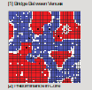
The draft contains a numberofvideos that illustrate how the presence of physical venues modify the classic segregation processes described by Thomas Schelling, generating distinctively spatial patterns of order and change.
Thomas Schelling’s classic paper is a key reference point for agent-based models of segregation. It is often taken as providing fundamental insight into the micro-processes that produce the segregated macro-structures that characterize urban settlement patterns. In this research tradition, however, urban form plays a very limited role, despite the fact that Schelling himself introduced his model by reference to venues (such as churches) and spatial areas (such as neighbourhoods). Form is generally reduced to an agent’s capacity to ‘see’ nearby grid-cells of the simulation world: an agent’s neighbourhood is its Moore neighbourhood.
In this research, we argue that an analytically meaningful simulation of neighbourhood formation – or more specifically of integration and segregation dynamics – must acknowledge the role of built form. We introduce a model of physical venues into the classic Schelling model in order to reconsider the simulation’s dynamics as influenced by both the spaces where agents live and the spaces of their activities. Venues structure the urban environment because i) they are foci of interaction and ii) their number and physical distribution constrains agents’ behaviour. Articulating and observing the consequences of some simple rules for the interaction between agents and venues, we are able to generate characteristic combinations of integration and segregation that have distinctive urban features lacking in typical Schelling-type models. Moreover, whereas in Schelling-inspired formulations, once a pattern of segregation congeals it is nearly impossible to change, we show that under some circumstances shifting the location of venues may break or redefine underlying patterns to some degree.
In a series of four case studies of increasing sophistication, we observe novel combinations of integration and segregation, brought about by the interaction between agents and venues. In our first study (1), we investigate different spatial configurations of venues from simple geometric distributions to a core and periphery model. Findings highlight the more realistic settlement patterns emerging from the interplay of a planned configuration of venues and the self-organizing behaviour of agents. In our second study (2), we consider variations in a venue’s exclusivity – the extent to which venues of a given group are open to admitting members of other groups. We discuss the parameters under which a range of outcomes result, from integration made possible by adjacent and exclusive venues, to ‘co-opting’ that can be caused by highly inclusive venues. In the third study (3), we build on prior experiments in the literature that have examined unequal populations, and demonstrate how majority/minority dynamics are affected by the presence of physical venues. Finally (4), after noting the high stability of segregated outcomes in Schelling-style simulations, we apply our venue model across a range of parameters in order to evaluate conditions under which settled, segregated neighbourhood patterns become disrupted.
In addition to their particular substantive points, a persistent interest of these studies is whether – and under what parameter ranges – access to group-specific venues allows individual agents to be comfortable remaining in a more diverse neighbourhood vs. these same venues becoming attractors that reinforce Schelling dynamics of segregation. In the process of introducing the case studies, we also describe and deploy a series of methodological innovations. For example, we begin each study with a visualization of the variety of simulation outcomes across value ranges of two input parameters (for example “intolerance threshold” vs. “max travel distance”). These representations, which we refer to throughout as parameter spaces of the simulations, organize the discussions of our findings and allow us to emphasize significant steps or thresholds, where small changes in the input parameters yield large changes in the results (Schelling’s classic example of which is the intolerance threshold around 1/3rd). Where necessary, we also introduce specific techniques of visualization and analysis to effectively characterize the movements of agents and the resulting patterns of clustering in relation to the built form of the simulations.
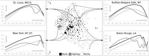
To understand how the relationship between musicians’ unconventionality and popularity varies across cities, we built in interactive visualization tool. It can be accessed here.
The tool allows a user to compare cities in terms of the musicians that are located there. Across cities, there tends to be an “inverted U” pattern, whereby musicians that are “too conventional” or “too unconventional” are penalized, while bands that exist in the “sweet spot” between the two are relatively popular. However, the shape of this relationship varies depending on the city.
Cities are breeding grounds of distinct modes of cultural activity. In this study, we examine how popular musicians define themselves differently depending on their location. In particular, we examine the relationship between bands’ degree of conventionality and unconventionality and their popularity. We show that this relationship in general exhibits a non-linear, inverted U pattern: extremely conventional bands are relatively unpopular, somewhat unconventional bands show more popularity, while the most unusual bands are not very popular.
However, this general pattern shifts, across musical genres and geography. Some cities show greater receptivity to unconventionality, with more unconventional bands achieving greater popularity, while in others more conventional bands tend to thrive. We examine several features of the urban environment that might explain these variations. We do so using a large database of nearly 3 million band profiles from myspace.com, circa 2007.
An interactive tool for exploring these relationships can be accessed here.
While cities as a whole can be viewed as distinct ecological environments, they also have their own internal ecological order made up of a variety of local niches. These niches are not independent of one another, but interact to produce and reproduce a characteristic order that persists through time, even as individuals move about and change. In this study, we examine and develop the notion of the political order of the city as constituting a crucial aspect of urban ecology, using Toronto as a case study but also exploring similar relations in London, UK.
To do so, we combine insights from urban studies, political science, and geography to examine the spatial articulation of urban politics. We deliberately speak of a “political order” rather than a “political structure” to emphasize relational patterns while allowing for change in, and selective activation of, their ordering principles. We develop a framework for examining urban politics that features three core concepts: order, cleavage, and activation. Regarding order, we suggest that neighborhoods exhibit political patterns that tend to persist across elections. These patterns embody spatially-entrenched cleavages, which inform neighborhoods’ relationships to the city as a polity, as well as other neighborhoods. We suggest that cleavages become politically salient must be activated through mechanisms such as political campaigning, and that activated cleavages may in turn alter the views and experiences of residents in city neighborhoods.
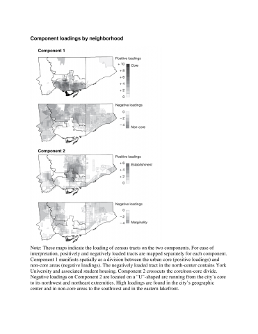
We find that Toronto’s political order revolves around two major cleavages. One divides the city’s progressive core from its more conservative suburban areas, and turns primarily on features of urban form and transit patterns, such as housing type and commuting method. The other is primarily intra-suburban, and divides the city’s traditionally upper-status Establishment areas from its more marginalized communities; this cleavage turns on factors such as income, religion, and occupation.
Having described the nature of Toronto’s political order, we then examine how it relates to individuals’ actions and attitudes, showing that individual Torontonians’ voting behavior is strongly connected to the particular political zone of the city in which they reside, and that individuals’ confidence in a range of social institutions shifts depending upon the political fortunes of their neighbourhoods. These analyses show that the meso-level ecological patterns we find are not readily reducible to the demographic characteristics of individuals; rather, the political order is a reality with significance in individuals’ lives, a social fact to which people respond in various ways.
Some interactive maps of Toronto based on this research have been published in the Toronto Star.