Our paper “Mapping Policy Pathways: Urban Referencing Networks in Public Art Policies” has been published in Urban Studies. This study grows out of a line of collaborative research on the topic of policy mobility (Keidar & Silver, 2022, 2023). Policy ideas — like the Percent for Public Art, the focus of our study — travel from city to city, and as they do, local actors adapt and revise them to their own context, while learning and comparing themselves to other cities.
While a large and thriving literature on policy mobility in geography focuses on local case studies, and quantitative research in political science focuses on the narrow question of whether a policy is adopted or not, our approach offers distinct methodological advantages. Our work draws on a large corpus of public art policy documents of all the largest cities in the Anglophone world (N=26) since 1959. With a grounded approach, we focus on the local meaning of such policy ideas, and with quantitative methods, we uncover the broader patterns that shape the “space of ideas.”
In “Mapping Policy Pathways: Urban Referencing Networks in Public Art Policies” we study how policy actors in one city refer to other cities in their policy documents. Policy actors routinely look to other cities as reference points – as models, comparators, or more – when they formulate their own local policy ideas. “Mental maps” emerge, but they do not exist only in individuals’ heads: they are embedded in policy statements that create and recreate international inter-referencing networks. Our paper uncovers the structure of these patterns of referencing networks and examines their underlying structure, guided by two key questions:
- What are the contours and attributes of the referencing network?
- Who are the cities that emerge as prominent reference points, and why?
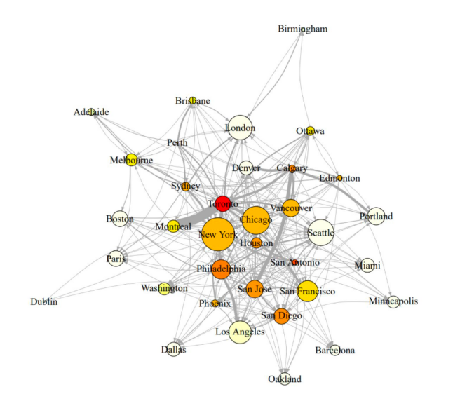
We built the reference network by identifying all instances of each city name in each document in our corpus. From this, we generate a network, in which two cities are connected if one city mentions the other. The strength of each connection is determined by how often one city mentions another.
Figure 1 shows the central result:

Note: The plot depicts the public art referencing network for our complete corpus of policy documents over the entire period under study (1959-2020), with nodes representing cities and edges representing the direction and intensity of referencing. Node size is based on in-degree centrality scores representing how many mentions each city received, and node color is based on out-degree centrality, with darker shades indicating cities that refer to other cities at higher rates. Edge thickness is proportional to edge weight, with thicker lines representing more referencing from one city to the other.
The most central cities of the public art referencing network are cities like New York, London, and Los Angeles. These are examples of what Bunnell (2013) calls “pathway cities,” those positioned at the top of the global hierarchy of urbanity, illustrating developmental pathway for other cities to follow. Other central nodes illustrate “policy description” cities, which presents a model for a policy strategy that can urge an urban transformation. For example, Chicago and Seattle – both recognized as leaders in the public art policy domain — are very central in the inter-referencing network, even though they are lower on global urban hierarchies. Montreal illustrates another form of centrality – captured by authority scores – in which it is highly referenced by other highly referenced cities.
With further regression analyses, we examine how attributes of the referenced cities, as well as contextual characteristics of referencing cities, correlate with these both types of centrality – degree and authority. Overall, the features of referenced cities have a strong and significant effect, while the contextual characteristics of the referencing cities are less salient. Among the attributes of the referenced cities, their global economic importance and their iconicism (mentions in experts’ lists of iconic artworks) have the strongest positive effect on the degree of references, and a weaker effect on the authority score. The significance of these factors alludes to the gravity of being a “pathway city” (Bunnell, 2013).
The authority score, however, shows the importance of policy expertise. It is found to be highly correlated with early adoption cities, and with members in UNESCO’s Creative Networks. This urban referencing network approach could be applied to diverse policy domains, like climate change, affordable housing, or smart cities. By revealing the distinct network contours and central nodes it helps uncovering how cities become policy models.
References:
Bunnell T (2013) Antecedent Cities and Inter-referencing Effects: Learning from and Extending Beyond Critiques of Neoliberalisation. Urban Studies, 52(11): 1983-2000.
Keidar N and Silver D (2022) The space of ideas: Public art policy and the concept of urban model spaces. Journal of Urban Affairs: pp.1-24.
Keidar N and Silver D (2023). Urban policy assemblage: Outcomes and processes of public art policy assemblage. Cities,138(May), 104365.

Leave a Reply
You must be logged in to post a comment.