
Temperature Check: Using Thermal Imaging to Assess Forest Health
Funded project by the Toronto and Region Conservation Authority featuring the Daniels Faculty’s Dr. Jonas Hamberg, Postdoctoral Fellow, and Associate Professor Patrick James.
We take our temperature to see if we have a fever. Now the temperature of trees can also be measured to determine the state our trees and forests. Scientists are beginning to use thermal imaging from drones and satellites to measure the health, growth, and recovery of forest systems.
For example: a tree that is stressed from pests, drought, or climate change will have a higher temperature than a healthy tree.
Until recently, there has not been a lot of research published in the field of thermal imaging and restoration, as the application of this technology is relatively novel
Jonas Hamberg, PhD, is one of the scientists using this innovative technology to research the health of Toronto regional forests over the next two years.
Funded by Toronto and Region Conservation Authority (TRCA) and Mitacs, Jonas is partnering with Dr. Jonathan Ruppert (Research Scientist, TRCA) and Dr. Patrick James (University of Toronto) over the next two years to use thermal-based imaging to evaluate:
- The cooling benefits of restored forests and other forest fragments, and the role they play in moderating the surrounding landscape temperatures
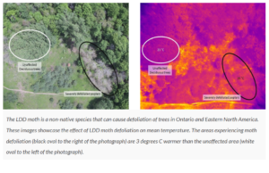
- The potential impact that LDD moths (Lymantria dispar dispar) have in the forests of TRCA conservation parks
Trees are Cool
Trees are nature’s air conditioners, cooling everything around them on hot summer days. Humans sweat when they get too hot, in order to cool down, and trees also cool themselves and their surroundings by transpiring water through their leaves.
This means that parks and forests can act as cooling centres for people and animals, and are critical infrastructure in mitigating and adapting to the effects of climate change.
But to what extent? How large do the treed areas need to be? Is the cooling effect increased by tree maturity and species diversity? Is it reduced by attacks from invasive species? And how much, and how fast, can forest restoration done by TRCA help to cool the environment?
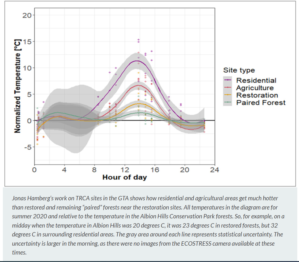
Thanks to research by Jonas and his collaborators at TRCA sites, we are starting to get answers to these questions.
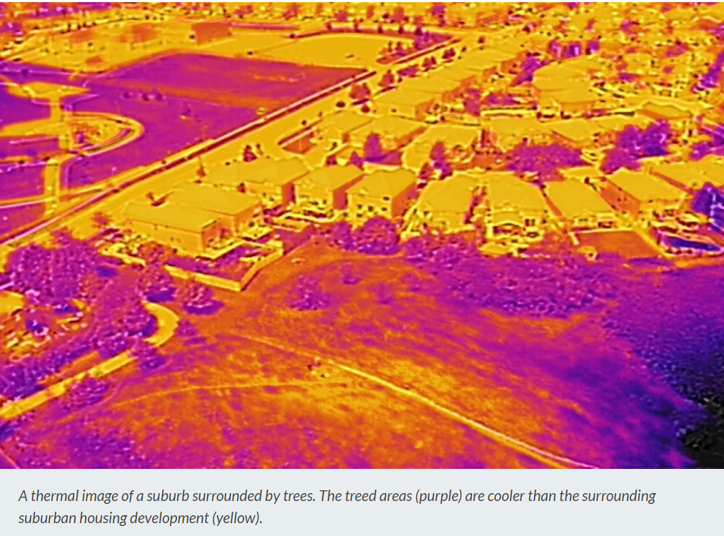
Using the thermal camera ECOSTRESS on the International Space Station, the team have found that treed restoration sites do experience less severe midday temperature spikes and less variation in temperature when compared to developed areas and agricultural fields.
Preliminary results show that restoration areas can decrease temperatures by an average of 0.1 degrees Celsius per year for an average summer day — or 2 degrees C over a period of 20 years. What’s more, restoration areas were found to be up to 8 degrees C cooler than surrounding urban areas on a sunny summer afternoon!
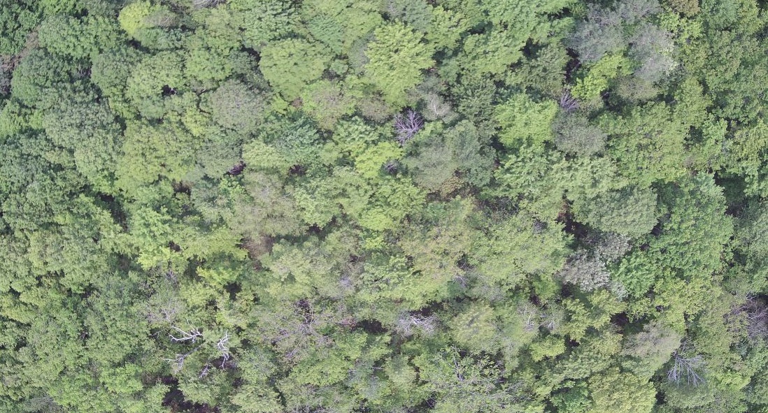
To expand on this research, Jonas has captured thermal images of forest and meadow areas in TRCA’s jurisdiction. The goal is to determine the cooling benefits the forest patches provide at these sites, and relate this work to future climate change scenarios.
The research is also examining how well regional forest patches cool the landscape, including fragments of mature forests, restored forests, agriculture, and peri-urban or suburban residential areas.
Detecting Invasive Species with Thermal Imaging
The Mitacs and TRCA sponsored grant has also supported the use of a drone to capture thermal images of LDD moth defoliation at Heart Lake, Albion Hills and Glen Haffy Conservation Parks.
The goal of this work was to determine if thermal imaging can detect where defoliation occurs, and to further develop this technology as a tool to uncover the presence of invasive species. The next half of the year will be spent analyzing imagery to pinpoint findings.
LDD moth outbreaks occur every five to 10 years. The hope is that this technology can help with the management, identification, and mapping of locations and severity of the next LDD outbreak.
The work was also extended to TRCA’s long-term forest monitoring plots, where thermal images were documented to help evaluate the long-term effects of LDD defoliation.
ALBION HILLS VISUAL AND THERMAL- Click HERE for YouTube link
 Flying Flying High: TRCA Explores Imaging Technology

Beyond this research, TRCA is testing the benefits of using imaging technology to shed light on many conservation questions that need answers. Both an aerial drone and underwater drone have been used in a variety of projects, and new cameras with different imaging capabilities have been acquired.
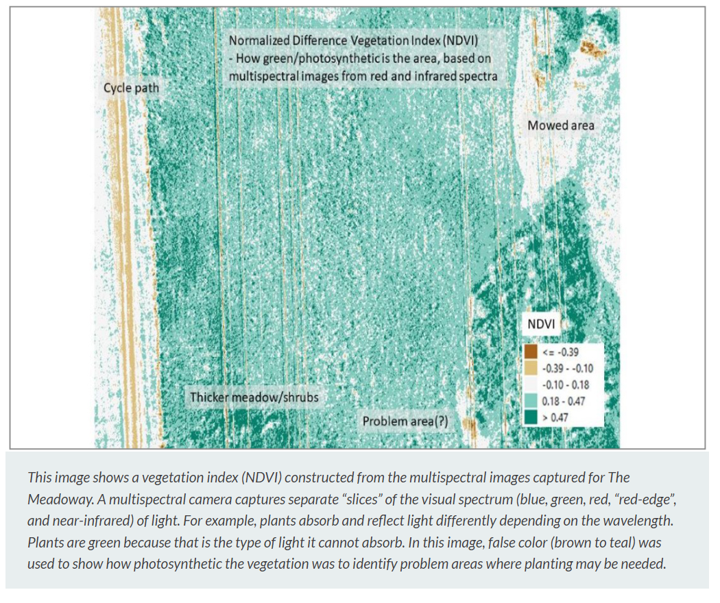
For example, a LiDAR camera, a multispectral camera, and a thermal camera are being used to assess different research questions for The Meadoway.
A multispectral camera is being used to determine if outbreaks of invasive species can be identified and mapped. Thermal imaging is also being used to compare the cooling benefits of different types of meadow and how they compare to turf grass.

Scientific data collection and research informs decisions affecting the natural areas and watercourses within our region. Connect with TRCA online.
Visit ECOSTRESS to learn more about the use of thermal imaging by the International Space Station, a collaboration with NASA and the Jet Propulsion Laboratory at the California Institute of Technology.
Click HERE for link to original article on the TRCA website.


